Time to Get the Science Right
While
the Indiana time flap may “reflect the governor’s lack of leadership,” as
suggested in a headline of the South Bend Tribune on December 1, 2005, the
ensuing commentary
reflects a common lack of scientific understanding.
The author stated, “If we want the sun to be overhead at
At
no place in the continental United
States is the sun ever
overhead. The sun only reaches the
zenith for people who live between the tropics, with 23 ½ degrees of northern latitude being the
most northern location to experience an overhead sun.
From South
Bend, Indiana, (assuming a longitude of 86 degrees 15 minutes West and a latitude of 41 degrees
41 minutes North), the sun peaks at just over 70 degrees of altitude around the
June solstice. In late December,
the sun only gets about 25 degrees above the southern horizon at its highest
point.
Left: http://www.solarnet.org/IndHome/Analemma.gif. Right: |

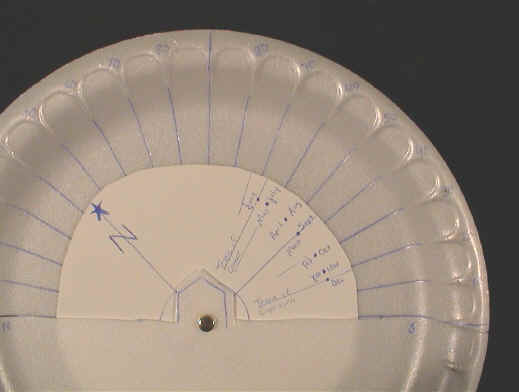 http://analyzer.depaul.edu/paperplate/Altitude%20of%20Noon%20Sun%20II.htm
What
I think the columnist meant to say in her commentary was, “If we want the sun to be at its highest point
above the horizon at
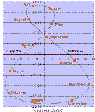 |
If
you were to track the sun’s
See http://www.analemma.com/Pages/framesPage.html for a tutorial on the analemma. |
Earth’s rate of revolution around the sun is not constant throughout the year, as proven on a sundial. Some days the sun is a few minutes “fast” and other days the sun is a few minutes “slow” in reaching its highest southern altitude. The analemma reflects the Equation of Time, the combined effect of the eccentricity of the earth’s orbit and the obliquity (or tilt) of the earth’s axis. It might seem like technical mumbo jumbo, but the analemma--the annual sun path--has a very real bearing on the time zone discussion and the validity of many people's arguments.
In
the diagram below, three analemmas show the sun's noon position throughout the
year for three different hours of interest in the discussion. The far right analemma shows the
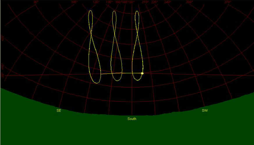
Diagram
in Coordinated Universal Time (UTC) depicts the
The
effect of Daylight Saving Time (DST) is to shift the analemma
left (east) one hour. If South Bend
were on
Central time (shown below in blue rows), the noon
analemma
would shift eastward from the right analemma to the
middle analemma.
Again, in South
Bend
the sun would be due south at
| Left Analemma | Center Analemma | Right Analemma | |
| Sun is well left (east) of south | Sun is left (east) of south | Sun is right (west) of south | |
| Central Time | 10:00 CST | 11:00 CST | Noon CST |
| Central Time | 11:00 CDT | Noon CDT | 1:00 CDT |
| Eastern Time | 11:00 EST | Noon EST | 1:00 EST |
| Eastern Time | Noon EDT | 1:00 EDT | 2:00 EDT |
On
Central time, South Bend gains the purported benefits of Daylight time by shifting the analemma
left (east) of due south for about seven months.
However, if South Bend started with Eastern time as
the baseline (i.e., our standard), the region would automatically gain the purported
benefits of DST simply by having its noontime analemma
left (east) of due south to begin with. During
Eastern Daylight Time (EDT), the benefit is further extended as the analemma
shifts left (east) even more. Of
course, this benefit is dependent on whether one acknowledges, say, the energy
savings gained from DST, of which the columnist was not convinced. More insight into Daylight Saving
Time is at http://webexhibits.org/daylightsaving/k.html.
Contrary
to the columnist's insistence that, in essence, the position of the analemma
“applies to the whole state, not just a few select counties,” the analemma varies with
one's location.
The annual path of the noontime sun, “a basic concept of natural
law " in her words, is easy to plot, even if one doesn’t have the “
Finally, if
your location straddles the primary meridian of longitude for your time zone,
your analemma is closer to the ideal “that nature
intended.” For the Eastern time
zone, the 75 degree meridian, shown below, is slightly west of

|
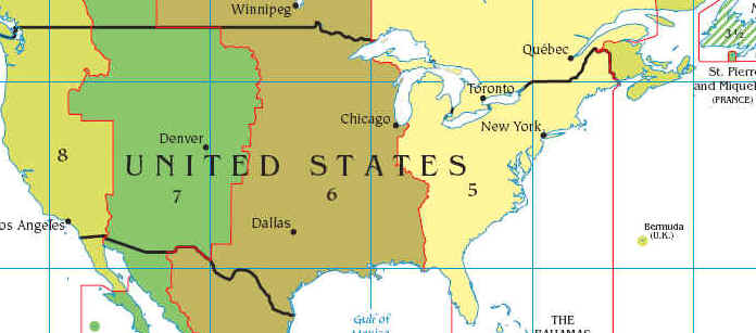
From http://upload.wikimedia.org/wikipedia/commons/4/4b/Timezones.png.
While
I have enjoyed the public discussion about time zones and DST, the newspaper
columnist has the
advantage of the pulpit. She may
preach her commentary at will, but I ask her and others not to propagate erroneous information.
Please do not declare your "common sense" to be scientific fact. It
gives Midwesterners a bad name.
Chuck
Bueter
Modified: 2005 December 2